
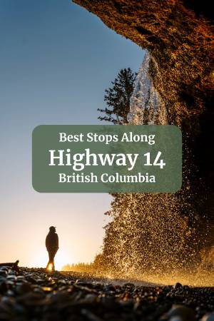
Before You Go
- Respect the yellow speed advisory signs. These appear before sharp turns and give you a real indication of how tight the corner is. In our Subaru Forester, we could take them a touch over the suggested speed, but in a larger vehicle, a van, or a camper, you will want to take them seriously. There is no good reason to be in a hurry on this drive anyway.
- Use the pullouts. Every few kilometres, there are pullouts along the shoulder specifically for letting faster traffic pass. Locals drive this road aggressively and will build up behind you. When you get a small convoy on your tail, pull over at the next opportunity and let them through. It takes 30 seconds, and everyone is happier for it.
- Watch for the one-lane bridges. Between Jordan River and Port Renfrew, the road narrows to a single lane at several points to cross bridges. Signs before each one will tell you whether to yield to oncoming traffic or proceed. Even when you have the right of way, slow right down. Visibility on some of these bridges is very limited, and the oncoming driver who is supposed to yield may not see you until they have already committed to crossing.
- Check the tides before you go. Several of the best stops on this route are tide-dependent. Mystic Beach and Botanical Beach, in particular, need to be timed around low tide. We use the tide forecast at tide-forecast.com and plan the day's stops around the low tide windows. It takes ten minutes of planning and makes a significant difference to the experience.
- Download Strava before you leave. More on this in the Sombrio Falls section, but Strava's heatmap feature is super useful for finding trailheads and paths on this route where signage is minimal.
Where to Stay (Before It’s Fully Booked)
The Must-See Stops
Shirley Delicious

About halfway between Sooke and Jordan River, Shirley Delicious is one of the best restaurant stops on the whole highway. The food is excellent, the garden patio is a great place to sit, and almost everyone eating there is doing some version of the same highway drive you are on, which gives the whole place a fun shared-adventure energy.
A few logistics worth knowing: they are open 8 am to 3 pm every day except Tuesday, and the kitchen stops taking orders at 2 pm. After 2, you can still pick up drinks and whatever baked goods have not sold out, but if you want food off the menu, you need to be there before 2. It is not table service. You line up, order at the counter, give them your name, find a spot inside or out on the patio, and they bring the food to you.
The line looks long but moves quickly. The breakfast burrito is the thing to order. I went back for it two days in a row on my last trip with the same order, and I have no regrets about that.
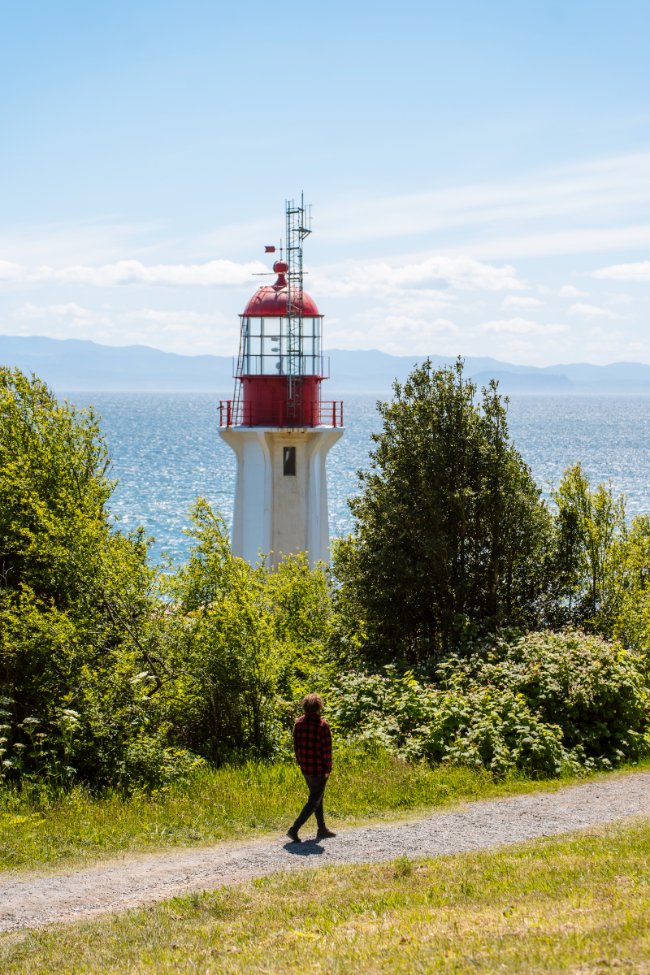
Sheringham Point Lighthouse
Sheringham Point Lighthouse sits about 30 minutes west of Sooke on Highway 14 and is one of the most photographed spots on the south island.
Getting there requires a short drive down a narrow road just past Shirley Delicious. Take the drive slow becuase the road is quite narrow but still has 2-way traffic.
The grounds are free to visit, but there is an optional donation at the entrance if you want to contribute to the maintenance of the site.
The walk from the small parking area to the lighthouse takes about five minutes along a flat gravel path and then a short descent to the shore.
The lighthouse is staffed by volunteers from the Sheringham Point Lighthouse Preservation Society, who have been restoring and maintaining the site for years. If the gate is open and someone is around, they are generally happy to talk about the history of the light and the restoration work.
There is a small museum next to the lighthouse as well, if you want to delve more into the history.


Stoked Wood Fired Pizza

There are a handful of places to eat along the highway, but Stoked Wood Fired Pizza stands out. They make wood-fired pizza, and they do not try to reinvent it or make it into something it isn't. They just make it really well.
The pizzas are thin crust and come in one standard size, around 12 inches, which is enough for a hungry person who has just finished the hike to Mystic Beach to finish solo without embarrassment.
The menu ranges from classic New York cheese to more creative combinations, and there is a vegan surprise option where the toppings are whatever the chef chooses that day. When we ordered it we got peppers, mushrooms, garlic, okra, and a pesto drizzle, which was excellent. They also have a small gift shop inside with handmade pottery and some good, locally made souvenirs.
You order at the counter, and they bring the pizza out to you in their branded boxes, which you can take to the patio or take with you to your next highway stop.
Jordan River


Jordan River is not quite a town and a bit more than a river crossing. People live here, and they will tell you they live in Jordan River, not Sooke, but there is no main street, no shops, and nothing really beyond some cottages, B&Bs, a strip of campsites, and one coffee shack. It is mainly known as a surf and camping spot, and the surf is less consistent than Tofino, but the vibe is good.
Cold Shoulder Coffee is right by the beach and worth the stop. It is a small outdoor setup with good coffee and solid baked goods, and you take your order down to the beach or sit at one of their picnic tables. There is no indoor space. They are open 9 am to 4 pm and closed Wednesdays and Thursdays.
Stop for a coffee, walk down to the beach, and spend 20 minutes taking in the coast before continuing west. The effort-to-reward ratio here is hard to beat.
Mystic Beach

Mystic Beach is the most talked-about stop on Highway 14, and it earns the reputation, but there are a few things worth knowing before you go, so you don't arrive with the wrong expectations.
The hike from the parking lot to the beach is a real trail, not a flat path to the sand. The terrain is rooty and can be muddy after rain, and it takes a good 45 minutes each way at a comfortable pace. Sturdy shoes, bear spray, and plenty of water are not optional. If you are planning to time the visit around sunset, pack a headlamp for the walk back because the trail through the forest gets very dark very fast once the light drops.
There is a shortcut some people use that involves parking along a narrow shoulder further up the highway and cutting down an unmaintained path to connect with the main trail. We do not recommend this. The parking is sketchy, the shortcut path is only suitable for experienced hikers, and the time you save is minimal. Take the main trail.
On the waterfall: manage your expectations. The Instagram videos of powerful falls with bikini-clad people frolicking in the mist are real, but they were almost certainly filmed in early spring after significant rainfall. In summer, when it has been dry, the falls reduce considerably less than that.
On our hike in, we passed several groups on the way back looking genuinely disappointed, and when we got to the beach, we understood why, because on that particular visit, the falls were barely a trickle. We had timed it for sunset, though, which saved the day, because Mystic Beach at sunset is a beautiful place to be, regardless of what the waterfall is doing.
Go at low tide if you can. Time it for sunset if you can manage both. Pack a headlamp either way.
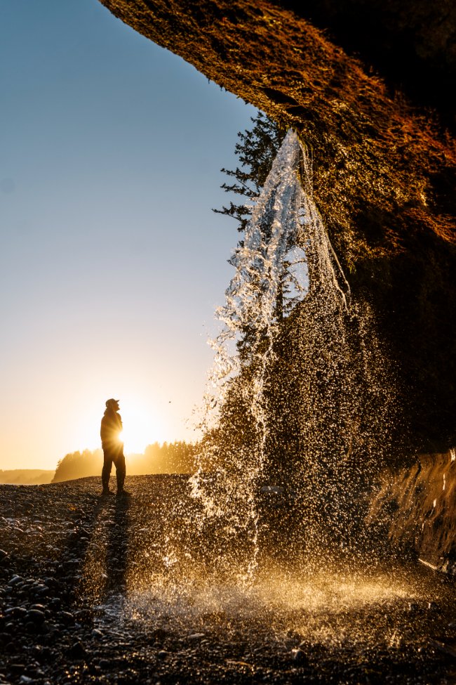
Sombrio Falls


Sombrio Falls is one of the most unique waterfalls I have seen on Vancouver Island, and I have seen a lot of waterfalls. What makes it different from every other waterfall on this list and most waterfalls anywhere is the way you experience it: the falls sit at the end of a mossy canyon that is essentially a cave, with a massive fallen tree spanning the opening and so much forest debris collected on top of it that almost no light gets in.
The only opening is at the far end, which creates a kind of spotlight effect directly on the waterfall. It looks like a bonus area in a video game. I checked behind the waterfall for a secret item, but there wasn't one.
Getting there takes a bit of effort, and the approach is a little unconventional, so read this carefully.
From the highway, turn off onto an unpaved road that is steep and rough in sections. Take it slow, and you will be fine. Our Forester had no issues, and the parking lot on the day we visited was full of low-clearance cars and old VW Golfs on nearly bald tires, so it is more manageable than it sounds.
From the parking lot, a short, steep path takes you down to the beach in about 10 minutes. Once you are on the beach, turn left. There is no trail. The beach is covered in large, rounded stones that are slow and awkward to walk on, and your footwear choice matters here more than on any other stop on this route. Sturdy waterproof boots are the right call.
Walk past the first creek. When you reach the second creek, follow the water into the forest and look for a scrambly path leading up into the canyon. This is where it gets wet. Depending on the water level, you may be walking through a shallow creek to reach the falls. You can try hopping between rocks, but it is easier to just accept that your feet are going to get wet and plan accordingly.
Finding the start of that canyon path at the second creek is the one part of this trip that trips people up. If you are not confident you will spot it, open Strava before you leave the parking lot and look at the heatmap for the area. You will clearly see where the majority of people turn off the beach and into the forest, and you will also see the cluster of people who overshot it and had to backtrack. It is a surprisingly useful tool for a spot like this.
Botanical Beach and Botany Bay


Just outside Port Renfrew, Botanical Beach is a must-do and possibly the best stop on the entire highway if you time it right. The keyword being time.
You need to visit at low tide. This is not a situation where visiting at low tide is a nice bonus. It is the entire point of being there. Aim to be in the parking lot about 30 minutes before the predicted low tide so you arrive at the beach just as the tide is pulling back to its lowest point, which gives you the longest possible window to explore.
At low tide, you can walk out onto the exposed rocky sea floor, which is freckled with tidal pools carved into the rock. Each pool is a self-contained little aquarium of real marine life: sea grass, starfish, sea anemones, and multi-coloured sea urchins in some of the deeper ones. Some pools are massive, and some are barely bigger than a bathtub, and each has its own little community living in it. You can easily spend two hours working your way along the coast, looking into pools. Watch where you step and do not touch, handle, or remove anything. The ecosystem is fragile, and the rules are strictly enforced.
The loop trail itself is about 4.5 kilometres with 100 metres of elevation gain and takes around an hour at a walking pace. It is more of a walk than a hike, and the path is wide and well-maintained, though you will want closed-toe sturdy shoes for the beach and the rocky headlands.
If you do the loop clockwise, you will reach Botanical Beach first, which is the right order. Continuing the loop brings you toward Botany Bay, but before you get there, look for the path that cuts out to the rocky headlands on your left. The rock formations out here are unlike anything else on this drive: layered sedimentary rock that has been tilted and twisted into formations that look like someone tossed a lasagna out of a pan and all the layers froze mid-air. You can scramble around on them at low tide. As the tide comes in, waves start reaching higher and higher up the rocks, so stay well away from the shoreline and watch your footing because the surface is awkward.
If you are visiting in late May or early June, or again in late September or early October, keep your eyes on the water and listen for the sound of whales exhaling. When we visited in May, we counted around seven Grey Whales feeding close to the shore and got a clear view of them surfacing repeatedly over the course of an hour or two. We went back the next day when the water was choppier and saw nothing, so it is not guaranteed, but it is worth watching for.
Parking is free, and the lot is large but fills up around low tide, so aim to arrive early, especially on a summer weekend.
Port Renfrew

Port Renfrew is where Highway 14 ends, and it is a small and unhurried place that does not really have a main street or a town centre to walk around, but it has a charming pub, a few good coffee options, and just past town, there is a long white sandy beach with a beautiful campground that is worth seeing even if you are not staying.
If you have been driving the highway for a couple of days and need a meal and a cold drink before turning around, Port Renfrew is a fine place to do it.
The Bonus Stops
These are the stops I would not prioritize over anything above, but they are worth making time for if your schedule allows.
Ella Beach


A large rocky bay right outside Sooke that would be a fine swimming spot in summer. The honest truth is that it is a good beach without a standout feature and there are more interesting options further along the highway, but if you are starting or ending your trip in Sooke and want a quick beach walk or a dip in the sea, it is right there and it's beautiful.
French Beach

A wide rocky beach with good coastal views and, importantly, picnic infrastructure: grassy areas, picnic tables, and fire pits. It is not dramatically different from the other beaches on the highway, but if you are with a group and want to stop somewhere with room to spread out and cook something, French Beach is the most practical option on the route.
Sandcut Falls

The third waterfall on the list is a solid one, just a step below the other two in terms of impact. The approach is actually easier than either Mystic or Sombrio: free parking in a small dirt lot with washrooms (pit toilets), a 5 to 10 minute path down to the beach, and then a 15 to 20 minute walk left along the rocky shore until you see the falls dropping directly off the sandstone cliffs onto the beach below.
Same caveat as Mystic Beach: this one dries up significantly without recent rainfall. Visit right after rain for the best waterfall, and know that it is a great sunset spot regardless of what the falls are doing.
China Beach

Accessed from the parking lot next to the Mystic Beach trailhead, China Beach is a short easy walk: about 2 kilometres return with 70 metres of elevation, taking roughly an hour. The beach is one of the few genuinely sandy ones on this route, which makes it good for a beach walk. You can also camp here but you are firmly in bear, wolf, and cougar territory, which means proper food storage is not optional. Also, make sure you've paid your backcountry fee, because they actively fine those who try to skip it. There are outhouses at the trailhead and near the beach.
How to Plan Your Time

The most important thing to sort out before you plan anything else is the tide schedule for Botanical Beach. Everything else on this highway is flexible, but Botanical Beach at low tide is the whole point of the drive and it needs to be the fixed point that everything else gets built around. Check the tide forecast before you leave home, lock in when you need to be at Botanical Beach, and then fill the rest of the day around it.
The good news is that the logistics are simple. You are driving the whole highway from Sooke to Port Renfrew and back anyway, which means every stop is on the route in one direction or the other. Shirley Delicious, Mystic Beach, Jordan River, Sombrio Falls, and the rest of the beaches all fall along the same road, so the order you hit them in does not really matter.
If the low tide window is in the morning, drive straight to Botanical Beach first and work your way back through the other stops on the return. If it is in the afternoon, work your way west through the stops and time your arrival at the beach to line up with the tide on the way out to Port Renfrew.
Final Thoughts
Sooke is a great base for exploring this stretch of highway. On our last visit, we stayed in Sooke the whole time and ended up driving some parts of the highway several times in order to explore everything in depth and line up spots with low tide and sunset.
Sooke is more than just the gateway to this road trip, though. If you're spending a few nights here, consider spending a day in East Sooke Park doing a coastal hike or just chilling at one of the beaches, and also a day in Sooke Potholes Regional Park is well worth the time as well. Between amazing views of the powerful Sooke River, waterfall hikes, and top-notch swim spots, it's a local and tourist favourite alike.
FAQ
How long does it take to drive Highway 14 from Sooke to Port Renfrew?
Which stops on Highway 14 are tide-dependent?
How do you find Sombrio Falls?
Are the waterfalls on Highway 14 worth visiting in summer?
What kind of vehicle do you need for Highway 14?
Our Trusted Travel Partners
We only recommend products and services we personally use and trust.

SafetyWing
Travel medical insurance for nomads and remote workers
Booking.com
Find the best deals on hotels, apartments, and vacation rentals
AllTrails
Discover hiking trails with detailed maps and reviews
Surfshark
Secure VPN for safe browsing and accessing content worldwide
Get Your Guide
Find the best deals on tours and experiences
Airalo
Prepaid SIM cards for travelers
Trusted Housesitters
Find free accommodation by house and pet sitting worldwide
Wise
Send and receive money internationally with low fees* We may earn a commission when you make a purchase through our affiliate links, at no extra cost to you. We appreciate this support, which helps sustain our blog and allows us to create more content and help more great trips get planned!